http://beforeitsnews.com/beyond-science/2013/03/kgb-map-of-alien-bases-on-earth-2441398.html
KGB Map of Alien Bases On Earth
Wednesday, March 20, 2013 20:59
There are many reports of underground bases reported around the world.
A comprehensive list can be
found here compiled by
Bibliotecapleyades and another list can be found here
compiled by
UFO-Aliens.
New York City
There is an entrance to the tunnels in New York City "in the vicinity of
Midtown Manhattan that can be reached through an abandoned elevator shaft that
only very few know about
The Nahanni Valley (Canada) Entrance
This covers 250 square miles in the southern end of the Mackenzie Mountains of
Canada. It lies almost 550 miles due west of Fort Simpson on the Mackenzie
River of northwest Canada. Hot springs and sulfur geysers keep the valley
warmer than the surrounding areas by about 30 degrees year -round (the valley is
above 60 degrees latitude), making it perpetually mist-covered. This valley is
inhabited only by animals as people entering the valley are usually found
headless and quite dead. The Indian tribes of the area avoid this valley.
(These tribes include the Ojibways, the Slave, the Dogribs, the Stoney, the
Beavers and the Chipweyans.) This valley is often referred to as "the
Valley of the Headless Men.
The Liyobaa Cave Entrance
This was sealed off by Catholic Priests who believed it to be an entrance to
"Hell." "The village of 'Liyobaa' or to translate, 'The Cavern
of Death,' was located in the province of Zapoteca, somewhere near the ancient
village of 'Mictlan' or the village of the 'Underworld.
"The Cavern of Death was actually located in the last chamber of an
eight chamber building or temple. This temple had four rooms above the ground
and four more important chambers built below the surface of the Earth. This
building was located in "Theozapotlan," and the tunnel entrance led
one beneath a mountain.
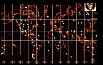
KGB Map of Alien Bases On Earth
United States Underground Cities,
Bases and Tunnels Systems
GOVERNMENT MAP OF UNDERGROUND
TUNNELS
These areas were found off a government
map showing just some of the underground bases in the United States.
EDWARDS AIR FORCE BASE :From
Edwards a tunnel goes to Vandenberg Air Force Base From Vandenberg you back up
to Edwards and go Southeast to subterranean base at a place that the map
designates as Cat., which probably means Catalina Island, showing a flying
saucer there so alien space crafts are probably seen there.
The map shows an underground base
and a tunnel going into it at a place called 29 palms.
The next place on the map where an
underground base is, is the Chocolate Mts.
There appears to be a site in
Nevada at Tonopah, Area 51 at Groom Lake, and a place designated as COG AFB.
In Arizona we have sites at Wickiup
and Page.
Utah there is one at Salt Lake City
(R&D AFB).
There is one in Riverton
"M", Denver, Colorado, Colorado Springs, COG Creedo and Delta.
In New Mexico they are at Dulce,
Taos, Los Alanos, ALB, AFB, Datil and Carlsbad.
In Texas there is one at Lubbock.
Denton "908" (C.O.G) seems to have an isolated one, Ft. Stockton and
in Old Mexico there is one at Chihuahua.
Tulsa Oklahoma has one and just NE
of there we appear to have one with a saucer coming out of it.
Hutchison AFB Kansas has one.
Google Earth UFO Alien Human
Secret Base
Arizona Tunnels and Caves
GRAND CANYON - Cave[s] near the
confluence of the Colorado and Little Colorado rivers. Hopi legends say that
their ancestors once lived underground with a friendly race of "ant
people" [not to be confused with the sinister "mantis" people
described by several abductees], but some of their kind turned to sorcery and
made an alliance with lizard or serpent men known as the "two
hearts", which dwelt in still deeper caverns below. The "flood"
of evil and violence forced the peaceful Hopi's to the surface world. An
explorer named
G. E. Kincaid claimed to have found "one of" the
ancient caves, in which were reportedly discovered Oriental, Egyptian &
Central American type artifacts.
Smithsonian archaeologists S. A.
Jordan and associates also explored the man-made cavern with hundreds of rooms,
enough to hold over 50 thousand people. The underground city is about 42 miles
up river from El Tovar Crystal Canyon and Crystal Creek, and about 2000 feet
above the river bed on the east wall. John Rhodes after 3 years of field
research reportedly discovered the Grand Canyon city, which is now being used
as a museum for elitist groups and has lower levels that are being used by
"super secret black book operatives", which can only be entered via a
stainless steel door at the bottom of a stairwell deep within the
"city" that is "guarded by a very lonely soldier staring into
the darkness... dressed in a white jumpsuit and armed only with an M16 assault
rifle to ward off his imagination."
Source: ARIZONA GAZETTE, March 12,
1909 & April 5, 1909; Robert Morning Sky; John Rhodes
Top Extra Secret Underground
Alien Bases, Part 1.
South America
Karl Brugger, in his book
The Chronicle of Akakor (Delacorte Press., N.Y., 230
pp), gives the history - as given to the author by one of their chiefs - of the
Ugha Mongulala tribesman, whose ancestors were allegedly part of a vast empire
which covered South America in ancient times. Some of these ancient people, the
chief claimed, left the planet in aerial vessels to explore other parts of the
solar system and beyond, leaving behind vast subterranean cities beneath the
Andes mountains and western Brazil.
In 1971, due to the constant
encroachment of white settlers or invaders into their territory, 30,000
survivors of the Ugha Mongulala allegedly escaped to this ancient system of
underground cities, consisting of 13 separate subterranean complexes all
connected by tunnels, one of which is said to extend to Lima, and others of
which are located throughout the Andes Mountain range of Peru.
Saga Magazine's UFO Annual [980,
p4], under the heading 'Cave Martians', described a bizarre encounter with
subterranean creatures which seemed to have consisted of some type of
automaton-like forms, perhaps on a reconnaissance mission from an underground
civilization. The story involved a tunnel near Xucurus, Argentina(?), some 90
miles from Buenos Aires. The tunnel was discovered by agriculturalist Gerardo
Cordeire, and found to contain nine connecting passages and strange
inscriptions on the walls.
From it's entrance "men nine
feet tall, green, with antennas on their heads, and square legs" were seen
to emerge, and which, according to hundreds of witnesses from the town and
nearby locals, resembled enormous "portable radios."
Camouflaged
"Alien Bases" on our World
"There is an ancient legend
among the Hindus of India that tells of a civilization of immense beauty
beneath central Asia. Several underground cities are said to be located north
of the Himalayan mountains, possibly in Afghanistan, or under the Hindu Kush.
This subterranean Shangri-la is inhabited by a race of golden people who seldom
communicate with the surface world. From time to time, they travel into our
land through tunnels that stretch in many directions. Entrances to the tunnels
are believed to be hidden in several of the ancient cities of the Orient.
Tunnel entrances are said to be in Ellora and the Ajanta caverns in the
Chandore Mountain range of India."
Eric Norman
BRAZIL
One tunnel in Brazil is near Ponte
Grosse in the state of Parana. (Fruit orchards were seen here.) Another
entrance in Brazil is near Rincon, state of Parana. Also, in the state of Santa
Catarina, Brazil, near the city of Joinville there is a mountain containing an
entrance to the tunnels. (Santa Catarina is an area alive with subterranean
activity, including strange 'singing' from underground.) Another entrance in
Brazil is in the state of Sao Paulo near Concepiao. Still another entrance in
Santa Catarina near Gaspar has subterranean fruit orchards.
"The states of Santa Catarina
and Parana, Brazil are honeycombed by a network of Atlantean tunnels that lead
to subterranean cities."
Alien Base in Scotland
The Maltese Cave Entrance
This entrance is located on the island of Malta, near the small village of
"Casal Paula." (This village is built on the "Corradino"
plateau, and overlooks the capitol town of Malta, "Valletta," as well
as Grand Harbour.) In 1902, workmen digging a well in Casal Paula fell into a
subterranean cavern. The well was being dug for a house on "Hal
Saflienti," the main street in Casal Paula. The cavern the workers had
fallen into connected with an entire complex of caves and tunnels. This
entrance is known as the "Hypogeum of Hal Saflienti." (In Latin,
"Hypogeum" is the name for an underground structure.) "The
tunnels under the Hypogeum have been sealed off even since a school took 30
students into the caves and disappeared, guide and all. Search parties were
never able to locate any trace of the people and children.
The Staffordshire, England Entrance
Somewhere in Staffordshire, England, a lonely field exists in which a laborer
discovered a large iron plate beneath the dirt. The "hatch" was large
and oval, with an iron ring mounted on it. This entrance led into the tunnels.
The field is in a valley surrounded on almost all sides by woods. The laborer
was digging a trench for some purpose. The incident was reported in "A
History of Staffordshire" by Dr. Plot, who wrote the book in the late
1700s. It may be possible to find the entrance if it can be ascertained exactly
which valley the laborer was digging in.
The Dulce, New Mexico Base
An underground Military Base/Laboratory in Dulce, New Mexico connects with the
underground network of tunnels which honeycombs our planet, and the lower
levels of this base are allegedly under the control of Inner Earth beings or
Aliens. This base is connected to Los Alamos research facilities via an
underground "tube-shuttle." (It can be assumed that such a shuttle
way would be a straight-line construction. It should then be possible, by using
maps and some deduction, to determine the most likely location of this base,
especially since the general location is already known.) Beginning in 1947, a
road was built near the Dulce Base, under the cover of a lumber company. No
lumber was ever hauled, and the road was later destroyed. Navajo Dam is the
Dulce Base's main source of power, though a second source is in El Vado (which
is also another entrance). (Note: The above facts should also help to locate
the base.) Most of the lakes near Dulce were made via government grants
"for" the Indians. (Note: The September, 1983 issue of Omni (Pg. 80)
has a color drawing of 'The Subterrene,' the Los Alamos nuclear-powered tunnel
machine that burrows through the rock, deep underground, by heating whatever
stone it encounters into molten rock, which cools after the Subterrene has
moved on. The result is a tunnel with a smooth, glazing lining.)" (Note:
Where would the molten rock go? And what has been done with this concept since
1983?)
Bechtel (BECK-tul) is a super secret international corporate octopus,
founded in 1898. Some say the firm is really a 'Shadow Government's working arm
of the CIA. It is the largest Construction and Engineering outfit in the U.S.A
and the World (and some say, beyond)." "The most important posts in
U.S.A. Government are held by former Bechtel Officers. There are over 100
Secret Exits near and around Dulce. Many around Archuleta Mesa, others to the
source around Dulce Lake and even as far east as Lindrich. Deep sections of the
Complex connect into natural Cavern Systems. (Note: The elevators, lights, and
doors at Dulce Base are all magnetically controlled.)
The area around Dulce has had a high number of reported Animal
Mutilations." The researchers at Dulce Base have also abducted several
people from Dulce's civilian population and implanted devices of various types
in their heads and bodies. (Note: Livermore Berkeley Labs (where?) began
producing blood for the Dulce Base in the mid 1980s, and Human and Animal
abductions slowed considerably. It may be worthwhile to check-out Livermore
Berkeley Labs.) DELTA group (from the National Recon Group) is responsible for
security of all Alien-connected projects. The DELTA symbol is a Black Triangle
on a Red Background. Dulce Base's symbol is a Delta (triangle) with the Greek
Letter "Tau" (t) within it, and then the entire symbol is inverted,
so the triangle points down, and the "Tau" is also inverted. Christa
Tilton (was abducted and taken to Dulce Base) She is the editor of
"Crux" magazine, which deals with UFOs, abductions, etc. P.O. Box
906237 Tulsa, Oklahoma (zip ?????)
Bases in the United States Mt. Ranier, Washington State Mt. Lassen, Tehama
County, California Death Valley, California Superstition Mountains, Arizona Mt.
Shasta, California Brown Mountain, North Carolina Mt. Ranier Entrance.
A very active UFO base exists beneath Mt. Ranier. There are also said to be
underground "vaults" containing records of the ancient Lemurians.
(Note: F.L. Boschke wrote the book "The Unexplained" about the
mysteries surrounding Mt. Ranier.) The ice cap of Mt. Ranier contains a maze of
corridors and caves. In August of 1970, scientists climbed to the top of Mt.
Ranier, and entered these caverns and tunnels. Evidence was found indicating
that a small lake exists deep beneath the ice cap. It is possible that one
could find a way to get beneath Mt. Ranier through these tunnels.
The Mt. Lassen Entrance Mt. Lassen in Tehama County, California is an entrance
to a large underground city. Near the foot of Mt. Lassen is a town called
Manten. A man named "Ralph B. Fields" lived (lives?) there, and found
the entrance to the underground city. His friend "Joe" was with him.
The cave entrance is in the side of the mountain, at a little over 7,000 feet
above sea level, and is near a rock outcropping suitable for camping under.
Death Valley, CA. Entrance.
Local Indian legends speak of a tunnel that runs beneath the desert. (Note: The
book "Death Valley Men," tells the story of 3 people who are supposed
to have found an underground city connected with this tunnel, and who actually
took treasures from it. The entrance to the Death Valley Tunnel is in the
Panamint Mountains down on the lower edge of the range near Wingate Pass, in
the bottom of an old abandoned shaft. The bottom of the shaft is collapsed,
opening an entrance into a large tunnel system containing much treasure. These
tunnels connect with the surface also through arches (like large windows) in
the side of the mountain and they look down on Death Valley. They're high above
the valley now, but they were once on the edge of the water, and were accessed
by boats. The "windows" in the Death Valley side of the Panamint
Mountains are about 4,500-5,000 feet above the bottom of Death Valley, and are
across from Furnace Creek Ranch. From these openings you can see the green of
the ranch below you and Furnace Creek Wash across the valley. (So, with
high-powered binoculars or a telescope, you should be able to see the openings
from the Furnace Creek Ranch, or Wash.) You can drive down Emigrant Canyon
towards Death Valley. You can then park beside the road between Furnace Creek
Ranch and the Salt Bed. (From here, the windows should be visible through
binoculars.) Indian legends of the Paiutes Indians speak of the people who used
to live in the Panamint's caverns.
The Mt. Shasta, CA Entrance
There are tunnels beneath Mt. Shasta that lead to a UFO base there, as well as
tunnels that connect with the vast world-wide tunnel network. The Lemurian city
"Telos" is said to exist beneath Mt. Shasta. William Hamilton has
done much research on Mt. Shasta and the tunnels. He has privately published a
book entitled "Alien Magic" 249 North Brand Boulevard, Suite 651
Glendale, CA 91203
The Brown Mountain Entrance
Brown Mountain is in North Carolina near Morganton. Morganton is "about 15
miles north of an actual highway marker which has been posted by the state
providing any visitor the best view" of Brown Mountain. Brown Mountain is
an area in which many strange lights have been seen. There are entrances that
lead inside the mountain to an isolated (?) Alien base.


 IgNB-hGY or